Calumet Township
|
Calumet township is approximately 10 miles in
length and width. It is bounded on the north by Buffalo township, on the east by
the Mississippi River, on the south by Lincoln County, and on the west by
Buffalo and Prairieville townships.
According to the History of Pike County published in 1883, "there is no more beautiful body of land in Missouri than Calumet township." The area is noted for its majestic bluffs overlooking the river (one, the pinnacle at Clarksville, being nearly 900 feet above river level), its chains of hills called "Knobs" and its rolling prairies of both grass and trees. Calumet township is well supplied with watercourses, having Calumet Creek, Ramsey and Little Ramsey Creeks, Bryant's Creek, and Guinn's Creek with its tributaries. Thousands of fertile acres lie on either side of these streams, making the land's fertility unsurpassed in Pike County. Hidden springs supplement these waters and supply water to the towns within the township. Underlying the surface of the land in Calumet township is lime, clay for pottery and sandstone, as well as shale and many rocks and minerals. The area is considered archaeologically important, since skeletons of ancient man, pottery and artifacts and remains of the mastodon have been found by many an unsuspecting plow. The Indians left evidence of their presence in this area which once was teeming with bear, panther, wolf, bobcat, buffalo and fox. The Indians buried their dead on the pinnacle at Clarksville and used the land for farming. Of all the townships in Pike County, Calumet led the way with graveled roadways, the Calumet Road achieving nationwide recognition for its bicycle races in the 1890's when cyclists came from throughout the country to race about "the belt", as it was then known, for prizes and fame. "The belt" was a toll road extending out of Clarksville and along Route W to Turpin, then along Route WW to the intersection with Route D at Aberdeen, then along Route D to Dover, where it turned on to Route N and proceeded back to Highway 79 and then south to Clarksville to complete the circle. Pike County's toll roads were considered uncommon, if not unique, and the revenue from the tolls enabled the county to keep the roads in better repair than country roads elsewhere in the nation. In addition to having excellent roads for that time, Calumet also was a railroad center and Clarksville led the way towards having the first branch of extended railroads out of St. Louis. Eventually, this railroad went north to Hannibal. One of the rare features of Calumet township's winter season into the third millennium is the predominance of the bald eagle, the national symbol for the United States. Although these majestic birds are considered an endangered species, an unusually large number of them have chosen the Mississippi River at Calumet township for their winter home. Each winter, the island off Clarksville's shores (containing some 350 acres in the middle of the river) becomes a temporary habitat for the bald eagles who come to fish where the ice is broken up by Lock and Dam 24. Because of this predictable occurrence in recent years, Clarksville now holds annual "Eagle Days:" in January, when bird watchers from a wide area gather along the riverside to photograph and watch the eagles swoop down to catch fish with their strong talons. Also at this time, the Missouri Conservation Department and the St. Louis Audubon Society hold an official eagle count in Pike County. Calumet township's importance in Pike County's early history is evidenced by the number of communities which sprang up within its borders. Among these towns are: Annada, Calumet, Clarksville, Dover, Kissinger, Paynesville, Punkin Center, Sledd, Slemmensburg and Turpin. Several of these towns have slowly disappeared over the years.
The town of Annada was reportedly named by Robert McDaniel Smith, who was the first postmaster there. In choosing the name, Smith combined names of two sisters, Ann and Ada Jamison, daughters of Mr. and Mrs. J. Carson Jamison, who had donated land for some of the town lots. Annada is located in the southeastern part of Calumet township along Highway 79 and came into being in approximately 1837. Annada is distinguished by the Salt Petre Bluff which hovers above the town, standing 489 feet above the floodplain. The bluff is part of a Spanish land grant secured by Auguste Chouteau in 1798 consisting of over 7,000 acres of land. After Chouteau died, the land was divided and sold with William Sherwood buying the parcel containing Salt Petre Bluff for two dollars per acre. Sherwood, who was originally from North Carolina, then built a one-and-one-half story house out of hackberry logs on the north bank of Guinn's Creek. The site of this homestead is a quarter mile upstream from where the present Highway 79 bridge crosses the same creek. William Sherwood died in 1859. There is no evidence that salt petre was ever found in this bluff, however it is believed that this legend of salt petre deposits was begun by trappers and wayfarers of the early 1800's who tasted water from a spring which flowed from the west slope of the bluff. The water reputedly had a distinctive taste which was said to be salt petre. In the 1980's Annada has a population of approximately 100 people, a gas station, restaurant, grocery and a scattering of homes. The children travel by bus to attend Clopton schools. Several of the old churches still stand.
Several of the towns in Calumet township have long since dwindled to merely a name in history. One of these is Calumet, which in the early 1900's had a small post office on the old Clarksville gravel road where mail was delivered three times a week to the 30 inhabitants. The post office is now defunct. Calumet was located seven miles from Louisiana and seven miles from Clarksville (At Dover tollgate on Route D).
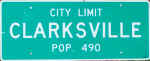
The largest town in Calumet township is Clarksville, located along Highway 79 approximately 10 miles south of Louisiana. The first settlers were believed to have been James Burns and Samuel Ewing. There are two theories as to how the town received its name. One is that it was named for William Clark, who was governor of the territory in 1817 when the town first took shape. The other theory is that Clarksville was named for General George Rogers Clark. According to legend, General Clark was heading north through Pike County with a company of soldiers on a keel boat, but the amount of ice on the river forced him to spend the winter in the Clarksville area. Legend also has it that the bluffs were abundant with rattlesnakes in the early 1820's and that one early settler, John Davis, once killed 700 rattlesnakes in one day on a knob near town. Clarksville has the distinction of having been nicknamed "Appletown" in the 1850's because of the amount of apples which used to be shipped from the docks there. In 1981, Clarksville reflected a determined spirit to thrive rather than go the way of many small towns once commerce begins to disappear. In the past 100 years, Clarksville watched as the ferryboat which once ushered travelers from Pleasant Hill, Illinois, to Clarksville was discontinued once the Champ Clark Bridge was built. Gone were the four thriving tobacco warehouses, the flour mill, the vinegar factory (whose cider and vinegar won prizes at the Chicago World's Fair in 1896), two hotels, the paper mill, the cooper factory, the Carroll House, the millinery stores, dressmaking shops, meat markets, bakeries, livery stables, the Opera House, and more. In 1880 Clarksville boasted a population of more than 1,400. By 1980 the census count was 585. In spite of this, the community has rallied to survive and Clarksville has won several awards for community improvement from 1965 to 2000. Some of these awards have come from paving 60 additional city blocks (for a total of 80 paved blocks); constructing apartment buildings; erecting a new medical center to attract both physicians and dentists to the community; installing a sewer system; developing a baseball field and children's playground; opening a Senior Citizens' Center; opening the Clarksville Historical Museum in 1980 and substantial rebuilding of the historic district. An extensive civic improvement was the transformation of an old Apple Shed on the outskirts of town into a county-wide arts center, the home for the Raintree Arts Council (a Pike and Lincoln County group dedicated to the preservation and expansion of art, theatre and history in the area). One of the contributors to Clarksville's successful community spirit has been the Southern Pike Community Progress Organization which came into being in response to a need for housing and development in 1961. Milton Duvall, Sr. was the first president. Their first project was the building of the medical center. Progress started long before the 1960's, however. Telephones came to Clarksville and spread throughout the farmlands of Calumet township as early as 1902. Electricity was introduced in 1920. The fire department was organized in 1936 and 20 blocks of Clarksville streets were paved in 1936-37 by the Works Progress Administration. Also in 1936, Lock and Dam No. 24 (one of 26 locks along the Mississippi River between Minnesota and St. Louis) was constructed at Clarksville, bringing some 200 workers and their families to the city. The lock has remained a popular tourist attraction bringing many visitors into Clarksville who might otherwise simply drive by. The Clarksville Sky-Lift, on the northern edge of town, another large tourist attraction, carried its passengers to the pinnacle (the highest point along the entire length of the Mississippi River) for a panoramic view 900 feet above the river. The Sky-Lift temporarily ceased operations in 1978, was re-opened in the summer of 1981 with new owners and has since ceased operations again. Clarksville is also the site of various fairs and activities each year. On July 4th, the town celebrates Independence Day with a fireworks display. (During the Bicentennial, a play was performed at Clarksville's riverfront part with 150 people in the cast.) Each year in October, Clarksville also has an Applefest sponsored by the Chamber of Commerce; historic home tours as part of the Fall Foliage Tour; and Eagle Days in January. Because of Clarksville's proximity to the Mississippi River, many of its historic homes are susceptible to floods each spring. One such home, known as Landmark, built in 1847, was used by early riverboat captains as a sighting. Its cornerstone bears the mark of the 1857 river flood and five subsequent marks as the river has flooded the home. The structure is considered a classic example of the architecture of the famed Christopher Wren of London.
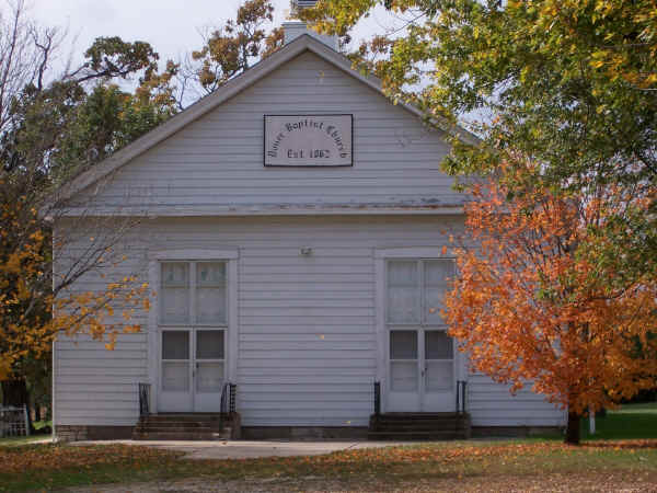
In contrast to Clarksville's relatively large stature in Calumet township, is Dover. Once a tollgate along one of Pike County's tool roads, all that remains of the "town" is the Dover Baptist Church along what is now Route D. The church was organized in 1862.
Kissinger was never much more than a station for the St. Louis, Keokuk and Northern Railroad. The station was built and named for Henley Kissinger. A native of Pike County, Kissinger was born in 1840 and was a successful breeder of superior stock. The station was located on his farm for the purpose of shipping stock and farm products.
Paynesville, situated in the southern portion of Calumet township, was founded in 1823 by Judge Andrew Forgey, who brought out the first settler, Thomas Buchannan, and established the first trading store to supply newcomers with necessities. Forgey laid out the town in 1831, but name it at least eight years earlier after William Payne, a wholesale merchant of St. Louis from whom Forgey had purchased his first stock of goods. The spelling of the name has ranged from PaynesVille to Painesville with several variations in between. In 1981, the town had only about 150 people and one general store with an adjoining post office which was later relegated to a rural route. The old Patton mansion and Forgey home are still standing, along with several other historic places. Paynesville still has three churches, but the school is gone and children are now bused to the Clopton schools.
The amount of historical information available about Punkin Center is as slight as the "town" itself. Punkin Center was at one time an old tollgate in Calumet township, located between Paynesville and Annada. It received its name from some of the people in the neighborhood who lovingly referred to the tollgate that way. The name stuck, however, the tollgate did not, and by 1981 Punkin Center was no longer on the map.
Sledd, located in the southwestern part of Calumet township, once had a store and a post office, both of which have been discontinued. The town was named for Alexander Sledd, the postmaster, who also ran the store with his brother, William. Another Sledd "landmark" was Smith's Mill, which was run by Levi Smith until the pressure of the law reputedly caused him to close down the business. Legend has it that a favorite transaction at the mill was to trade a bushel of corn for two gallons of whiskey. This was not popular with law enforcement officers during Prohibition.
Slemmensburg, located northwest of Clarksville in the northern part of Calumet township, was primarily a residential area and never had a post office. It was laid out as a real estate venture by J. J. Slemmens and was named for him. In the 1930's, a few black families were the only ones still living in the area.
Turpin, another town obsolete by the 1980's, was located three miles north of Paynesville at the junction of W and WW. It was named for J. Philip Turpin who came to Pike County in 1847 and ran a tollgate there. The tollgate was formerly called Hutt's Tollgate, in honor of the man who operated it. At one time, Turpin had a post office; however, this has long since been discontinued.
|

|
Cemetery Information |
||
|
|
||
|
|
|
|
|
|
|
|
|
|
|
|
|
|
|
|
|